Why Old Roads Follow the Valley Floor
Why old roads follow the valley floor becomes clearer when you read slopes, streams, terraces, and ridge gaps as clues to the route’s practical choices.
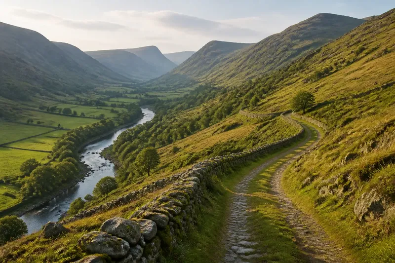
On a valley walk, an old road may keep to the flat ground beside a stream while a newer lane climbs toward a ridge. Why old roads follow the valley floor often comes down to the route a landscape made easiest to travel, though the lowest ground was not always the best ground.
A valley’s slope, water, and openings toward neighboring valleys all shaped possible routes. Bends, raised sections, and climbs can reveal how a road responded to those features, but they cannot establish a route’s age or purpose on their own.
How did a gentler gradient shape the route?
Steep climbs demand more effort from people, animals, and loaded carts than gradual rises. Valley floors often provide a lower-gradient corridor, but the easiest line may bend around small hills or follow a gentle incline rather than run straight.
Compare the road’s long profile with the nearby slopes. If it rises gradually along the valley while avoiding a steep hillside, its line may reflect a preference for manageable climbing. A modern road may cut across a slope more directly, so straightness alone does not identify an older route.
Say you find an old lane beside a river that bends around a low rocky spur. If the lane stays at a similar height through the bend, the detour may have traded distance for an easier passage.
On a walk, compare each bend with the ground beneath it.
Where can a valley lead beyond the local route?
Some valleys lead toward a pass, a broad saddle, or a lower opening between hills. These gaps can connect one drainage basin to another without requiring a climb to a higher part of the ridge, making the valley a link in a longer journey.
Follow the valley visually toward its upper end. A road that seems to wander may be heading for a notch in the ridge before continuing along another valley. Local geography can help explain which settlements a route connects, but it does not show who used it or why.
On a topographic map, contour lines crowd together on steep slopes and spread out across gentler ground. This can make a pass easier to identify than on a street map, which gives greater emphasis to present-day roads and place names.
How did streams help and hinder travel?
A stream can guide a route through enclosed country, but nearby ground may flood, erode, or become soft underfoot. A road may therefore run parallel to the water on a firmer terrace or along the valley’s edge instead of following the lowest ground.
A terrace is a relatively level step above the active floodplain, sometimes visible as a shelf along the valley side. A road following that shelf may have stayed near a useful corridor while avoiding wetter ground. Appearance alone cannot establish the reason: geology and later changes can produce similar shapes.
Look for a road that runs beside a stream at a higher level, then dips toward the water at a bridge or crossing. That pattern can suggest a balance between following the valley and choosing a suitable place to cross.
What can a road’s bends reveal about the land?
A winding route is not necessarily a poorly planned one. It may follow a stream bend, skirt a steep bank, or curve around a spur where the valley narrows. Each adjustment can help avoid a sharp climb or difficult ground.
Compare the road’s curves with contour lines, stream bends, and valley sides. A curve that follows a hillside’s broad shape may reflect the terrain; one at a modern junction or property boundary may have another explanation. On the ground, a change in slope or a cut into the hillside can make the turn easier to interpret.
Roads also change. Widening, straightening, bridges, and new embankments can obscure an earlier line, so treat a current route as a clue rather than a complete record.
What should you check when reading a valley road?
How can I tell whether a road follows a terrace?
Look for a level shelf above the stream and a road that tracks it while the valley floor slopes or becomes marshy. A topographic map can help distinguish the shelf from the lowest ground, but its shape alone cannot date the road.
Why does an old road rise out of the valley?
It may be heading for a pass, avoiding a narrow or wet stretch, or reaching a suitable crossing. Check whether the climb leads to a lower gap in the ridge or reconnects with gentler ground beyond it.
Can a winding road still be the easier route?
Yes. A longer path can avoid a sharp climb, follow a stable shelf, or bend around a spur. Compare the slope and setting with more direct alternatives before judging by distance alone.
Which map helps me read the landscape?
A topographic map shows changes in elevation through contour lines, while a detailed local map can help match the route to streams, bridges, and settlement edges. For a particular road’s history, consult local records or mapping rather than treating landform as proof.
How can several clues be weighed together?
No single feature explains every valley road. A gentle grade may have mattered alongside a stream crossing, a dry terrace, or a pass leading onward; together, these clues offer a more complete account than any one bend or map line.
- Check the slope: If the road follows a gradual rise and avoids a steep hillside, consider a lower-gradient route; if the climb remains sharp, look for another explanation such as a ridge crossing.
- Check for a terrace: If a level shelf sits above the stream and the road follows it, consider firmer ground as a factor; if no shelf is visible, compare the road with other changes in the valley.
- Check the water crossings: If the road dips toward a bridge or ford, consider whether access to a crossing shaped the line; if there is no clear crossing, do not assume the stream determined the route.
- Check the ridge ahead: If the valley points toward a low gap, consider whether the road linked onward through that opening; if it ends at a steep barrier, look for a different connection.
- Check the bends against the contours: If curves follow the hillside or skirt a spur, consider terrain as an influence; if they align with a junction or boundary, compare those features before attributing the bend to the land.
- Check for later alterations: If embankments, bridges, or straightened sections interrupt the line, treat the modern alignment cautiously; if the route appears continuous, still compare it with maps or local records before drawing historical conclusions.
Imagine a reader tracing an invented old lane on a topographic map. The starting clues are a stream below the road, a level shelf beside the hillside, a gradual bend around a rocky spur, and a low ridge gap farther up the valley. First, the reader checks the contour lines and sees that the direct route over the spur would cross steeper ground. Next, the reader follows the shelf and notes that the lane dips toward a bridge where the stream narrows. Then the reader traces the valley toward the gap and sees a gentler corridor beyond it. The resulting interpretation is that the lane may have combined a manageable grade, firmer ground, a crossing, and onward access; the map still cannot establish who used it or when.
When considering why old roads follow the valley floor, focus on changes in the route: where it stays low, rises, or turns toward a gap. Those transitions show how slope, water, and onward connections may have shaped the line, while keeping the distinction between a plausible reading and a proven history clear.